扫一扫,手机访问本帖 
|
Distance(round trip): <15km
Elevation Gain: ~1300+m
**时令调节,day light增长,这次集合时间改为7:30 @Production Way-University Station--方便坐sky train来集合的同学们***
日期: 本周六 (3月15), 2014. 7:30am
天氣預測:
Environment Canada
參加者基本要求:
團隊精神 - 共進共退,友爱互助 。分工合作,有FUN同享。
责任與備注:
1. 户外活動有風險,一切组織和活動屬自願,責任自負。
2. 一切計劃會跟據當時天氣, 環境作靈活變動, 隊友應跟隨整體行進, 不可單獨行動。
3. 一定要三人一組結伴同行。每組備對講機一部, 否則每組定要保持在視線範圍之內。
聯絡人: lulululu
司機注意: 如閣下持有Novice牌(Class 7), 除非在一名年滿25歲持有Class 1 - 5的人仕陪同, 否則只可接載一名乘客, 也一定是掛上"N"字標誌。請參閱 ICBC網站
對講機频道:6-6(6主频道,6子频道)
Carpool费用: $20
必需裝備:
1> lunch & snacks (午餐,能量棒若干,零食若干,不能帶蔬菜,水果,肉類過關)
2> 防水Hiking boots +Gaiter+雪鞋+microspikes (or Crampons)
3> 2升水 (带热水,不要用水袋,会结冰better to bring some hot water in the themos)
4> 一對手套+hat
5> quick dry base layer 和一套御寒保暖衣服(e.g. fleece/down jacket)
6> 防雨防风外套
7> 头灯/手电筒
8> Day hiking背包及rain cover
9>防晒霜,高山的紫外线反射很厉害
10>墨鏡
11> Gaiters,防雪防湿鞋湿裤又能防脏
12> 哨子
13> 登山杖
14> 雨具
一些注意事項:
需要CARPOOL的朋友准備两雙鞋(一雙是登山鞋),在開始Hiking前和結束後,换上乾淨的鞋,這樣省去車主打掃車内衛生,謝謝!還可以再准備一雙備用的襪子。爬完山,能讓脚舒服一下也是種享受 .
手套很有用,保暖防寒,要防水/快乾的。(如果没有防水/快乾手套也可帶二三雙羊毛手套濕了替换用)!
防雨防風外套/雨具和保暖衣服!
報名請說明開車或carpool
集合時間: / 集合地点:
***司機與乘客可以自行安排接載時間, 地點(安排好的车辆和人员请跟贴说明一下集合时间地点是7am Production Skytrain Station, Free Parking on both sides of Production Way (See details in the map below)
描述: 红线为 Free Parking 区域,no time limit, 准确集合位置见 Meeting area 箭头所指
 我会去那里集合 我会去那里集合
**如需carpool请跟贴说明住的大致地点***
报名者请务必填写下面链接里的表格:(向潘博士学习的,很好的有效管理和安全的召集方法, 谢谢!!)
https://docs.google.com/spreadsh ... XRGaTZvaWc6MQ#gid=0[/quote]
不需要四驱.
Driving direction:
Travelling east on Highway 1, take Exit 119(Sardis,Cultus Lake). Driving south through Sardis and Vedder Crossing to the bridge over the river, which is known as Chilliwack River upsteam of the bridge, Vedder River downstream. Turn left and zero your Odometer here. This is Chilliwack River Road. Drive east for 40km, and just after crossing Post Creek, park on the roadside.
Distance(round trip): <15km
Elevation Gain: ~1300+m
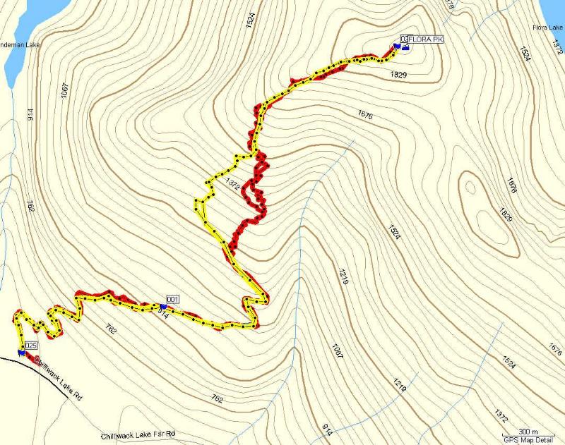
Flora Peak GPS Track from CT:

Info from Bivouac:
Flora Peak(1952M)
Ranges: Pacific Cordillera / Cascade Range / Canadian Cascades / Skagit Range
Flora Peak area

(23 km SW of Sunshine Valley). (2 km SW of Mount Wittenberg).
Flora Peak is the highest point of a pleasant, alpine ridge 2km N of Chilliwack Lake. A hiking trail leads to the saddle 500m SE of the peak before dropping to Flora Lake, 1km E of the peak and 730m lower. Flora Peak is easily ascended via its SE slopes from the saddle. In winter, there is a good ski descent from the open ridgecrest W of Flora Peak. The slopes further E and immediately S of the peak are steep and largely treeless and bare rock, sliding readily and funneling into a narrow canyon- a hazardous area receiving full S exposure and heating from mid-winter sun.
There are gargoyle features NW of the peak. If Flora Peak were steeper, there would be good climbing on it. Near its summit, the rock is blocky, well jointed and clean.
已报名:
lulu两人一车 |
|