|
|

楼主 |
发表于 2015-2-23 20:33:15
|
显示全部楼层
Info from Bivouac:
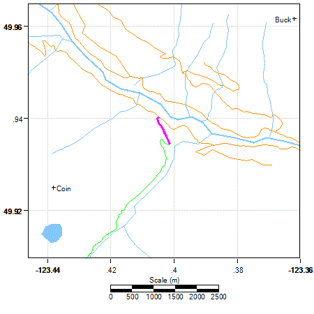
Ashlu A610 #1391 (Pokosha Spur)

Length:3.0 km Class: ? Spur3
Condition: 4WD HC for 800 meters. Park at a switchback. Badly washed out in a couple of spots shortly thereafter. Cleared for skiing.
General Route: Runs up the west side of Pokosha Creek. Upper branch crosses to east side.
Road Plan: Ashlu Road Naming Plan
How to Find: From Squamish, drive north on the paved Squamish Main 1, turn west onto Ashlu Main, cross the Squamish and Ashlu, then up Ashlu Canyon. At +6.5km, Ashlu main goes down to cross Ashlu Creek, but for Ashlu A610, you stay left and level. After this fork, you have now left Ashlu main and are now on A600 (the old mine road). Drive on A600 for +2 km and you see a second road going down to the dam. Stay left. Within 100 meters the improved part of the road ends, and the original A600 continues up toward the old Osprey mine. The road is now rougher as it goes uphill. You cross Pokosha Creek itself at ... At +3.8 on A600, look for the Pokosha Spur at 420m. It goes off left at right angles in the middle of a hill, very easy to miss when you are concentrating on driving up the hill. There is a small pullout for 2 vehicles on the right. The roadside ditch requires high clearance and low range to cross.
Short Description: The Pokosha spur leaves A-600 on the left (goes west) near the bottom of a hill about 1 km past Pokosha Creek bridge. The Pokosha spur itself forks twice more.
The road to the first fork was upgraded by Interfor in 2001 for heli-logging. The first fork is at about 0.8 km up from A-600, at 454m. Park here. The fork is tricky because you should not continue straight ahead, but should turn off to the right switchback up the hill. [The lefthand spur continues straight and crosses back across Pokosha Creek to some impressive avalanche slopes. It is shown as black dotted line on 1]
The second fork is at 710m. The two choices are to go left and drop to cross Pokosha creek, or stay right and continue climbing. The left fork is only used in spring on skis after avalanche debris off Pokosha Peak bridges Pokosha Creek. The right fork is more reliable and is used to approach Sigurd Lake and Mount Jimmy Jimmy. Pick up a marked and improved trail from road end of the right fork. current road condition by Simon Chesterton: Couple of Snow Patches at End
Information Date: 2015.02.16
A-600 has a washout area shortly past the road down to the intake pond and A-610 seems a little rougher than last year (in a couple of spots) but we got a Nissan X-Trail to the parking area 800m up A-610. An ATV has been further up that road recently to near end and the road is still easy on the feet to there and past with minimal snow cover. We left the trail at about 910m elevation (just past the slide alder) and followed flagging most of the way up to the lake. Continuous snow starts around 1200m elevation and was hard crusted all the way to Coin Peak.
4 pics by Simon Chesterton: |
-
by Simon Chesterton

-
by Simon Chesterton

-
by Simon Chesterton

-
by Simon Chesterton

|