开启辅助访问 切换到宽版

北美户外俱乐部

 找回密码
 注册
搜索
热搜: 活动 交友
查看: 24161|回复: 59

Fimmvruhls-Laugavegurinn Trail, Jul. 29-Aug. 11, 2016

[复制链接]
扫一扫,手机访问本帖
发表于 2015-9-17 21:38:29 | 显示全部楼层 |阅读模式
Trial info:
http://fi.is/en/hiking-trails/laugavegurinn/

https://northernadventures.exposure.co/fimmvruhls-laugavegurinn

http://adventure.nationalgeograp ... s_68710_600x450.jpg

http://worldy.ca/category/行走足迹/远足冰岛/

Itinerary:

Jul. 29, 2016 Vancouver —Reykjavik via icelandair FI696
Departure:        3:55PM
Arrival:        6:00AM +1 day
http://www.icelandair.ca
Bus info @ Reykjavik airport: http://www.kefairport.is/English/Transportation/Buses/

Jul. 30, 2016 购买燃料,休息,住Reykjavik
http://www.booking.com/hotel/is/ ... type=total&

Jul. 31, 2016 take bus to Skógar, start hiking FROM SKóGAFOSS TO FIMMVÖRDUHáLS
https://www.re.is/iceland-on-your-own/

Bus Schedule: http://www.nat.is/re/bus_stop_re_to_skaftafell.htm
(08:00etd Reykjavik,  11:20eta Skógar, 6000,00 ISK/person)

Aug. 1, 2016 FROM FIMMVÖRDUHáLS TO TóRSMÖRK

Aug. 2, 2016 FROM TóRSMÖRK TO EMSTRUR (BOTNAR)

Aug. 3, 2016 FROM EMSTRUR (BOTNAR) TO áLFTAVATN

Aug. 4, 2016 FROM áLFTAVATN TO HRAFNTINNUSKER

Aug. 5, 2016 FROM HRAFNTINNUSKER TO LANDMANNALAUGAR

Aug. 6, 2016 explore LANDMANNALAUGAR, and take bus back to Reykjavik

7 Aug. KEF to Jökulsárlón Iceberg Lagoon, Tjóevegur, Iceland, 420km, 5hr.
机场取车,南线经1号路沿路观景到Jökulsárlón冰河。5小时车程。
https://goo.gl/dUrcyS
stay 80公里外的Hofn.
https://en.wikipedia.org/wiki/Jökulsárlón

8 Aug.Hofn to Mjóafjarearvegur, Iceland, 350km, 5hr 30min.
Hofn向东350km, 游览东部峡湾区,Fáskrúesfjöreur,Reyearfjöreur,然后953公路至Mjóifjöreur.
https://goo.gl/aniujQ
stay at Egilsstaeir
https://en.wikipedia.org/wiki/Reyearfjöreur

9 Aug. Egilsstaeir, Iceland to Krafla, Viti 168km, 2hr, Namafjall Hverir, Myvatn,Goeafoss, to Blonduos 233km, 2h 50min
https://goo.gl/2BTIIn
Egilsstaeir向西168km,到米湖区域,游览Krafla火山湖,Namafjall Hverir地热区,转米湖( Hveraströnd Sulphur Springs,Dimmuborgir Lava Formations, The Skútustaeagígar Pseudo-craters,The Geothermal Caves),米湖温泉提供泡澡。向西开至1号/85号公路junction, 为上帝瀑布。再开往233公里外的Blonduos 或更西的小镇居住。
http://www.visithusavik.com/attractions/krafla-caldera/
http://www.myvatnnaturebaths.is/en/prices-hour

10 Aug. Blonduos to Snafellsjokull 260km 3h20min, to Reykjavik 190 km 2hr
https://goo.gl/iuM1Ci
Blonduos向西260km,开往Snafellsjokull公园,游览后开190 km返回首都。
http://www.snaefellsjokull.com/home

11 Aug. Reykjavik to Blue Lagoon 50km 39min, to airport 25km, 26min
转首都,开车到蓝湖泡澡,返回机场还车。
Reykjavik —Vancouver via icelandair FI697
Departure:        5:15PM
Arrival:        5:50PM

Hiking Passport: 12.500 ISK/person
https://www.re.is/iceland-on-you ... /hiking-on-your-own

Signed in (full):
Poker x 2;
Chris Xiao x 2;
桥梁 x 1;
麦芒 x 1;
磐石 x 1;
Frank Lu x 2;
Grace Guan x 2;

 楼主| 发表于 2015-9-17 21:44:28 | 显示全部楼层
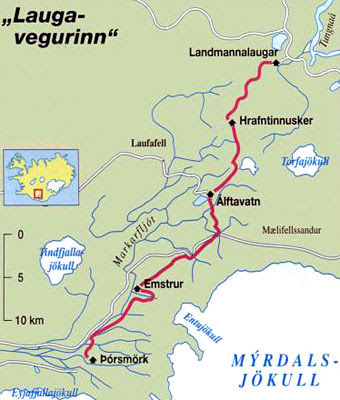
Laugavegurinn Trail 4天线路描述由北向南(我们是由南向北)

Day One: Landmannalaugar - Hrafntinnusker
12 km, 4 - 5 hours
Elevation increase: 470 m

Starting point is the hut in Landmannalaugar (75 beds, GPS N63°59.600 - W19°03.660). From there it’s an easy hike through the lava field of Laugahraun towards the colourful mountain Brennisteinsalda. There the gradual climb starts through dissected hills with views offering an incredible spectrum of colours. After 3 - 4 hours you arrive at Stórihver, a geothermal area with hot spring (unfortunately too hot to bath in).
About 2/3 of the way are very likely to be covered with snow until late summer. At an elevation of around 1000m fog can show up suddenly and without warning. The trail is clearly marked but hikers must be careful.
Hrafntinnusker hut (Höskuldsskáli) can accommodate 52 persons (GPS N63°55.840 - W19°09.700) and will show up suddenly and unexpected about 2 km after the memorial of an Israeli who died of hypothermia close to the track.

Evening walks: 20 minutes walk to Mt. Söeull (beautiful views) or 40 minutes walk to ice caves (collapsed in 2008). Ask hut warden for more information.

Day Two: Hrafntinnusker - álftavatn

12 km, 4 - 5 hours.
Elevation decrease: 490 m

The first part of the trail takes us through a valley with some small ravines but be careful as they may be filled with snow. A short and steep incline leads to the highpoint of today’s walk. If the visibility is good, a side trip to the summit of mountain Háskereingur (1281 m) will reward your with a breathtaking view. This is best done from its western slope, but care must be taken as a glacier is crossed. Ask the hut warden for further information.
If you stay on the main track, you’ll soon leave the colourful rhyolite mountains and enter an area with dark palagonite mountains and glaciers. You will also notice a considerable increase in vegetation. The trail down the Jökultungur is quite steep and care must be taken during the descent. The last few kilometers to the huts by the lake álftavatn is on flat land. The two huts take up to 52 persons (GPS N63°51.470 - W19°13.640).

Evening walks: a hike up Mt. Brattháls, which takes 1 - 2 hours return. Wet feet included as it’s necessary to wade the little stream coming from Lake álftavatn. Another hike is up Mt. Torfatindur (818m), estimated walking time 1 - 2 hours.

Day Three: álftavatn - Emstrur (Botnar)

15 km, 6 - 7 hours
Elevation decrease: 40 m

The trail takes us over the ridge Brattháls into Hvanngil ravine, wading across the small river Bratthálskvísl. In Hvanngil are two huts, one built for sheepherds in 1963 and one for tourists, built in 1995. As álftavatn and Hvanngil are only 5 km apart, Hvanngil can be used as an alternate accommodation. The huts can accommodate xx people, provides toilet facilities, showers and a small camp side inside an old lava field.

Leaving Hvanngil, a bridge crosses the river Kaldaklofskvísl. On the eastern bank of Kaldaklofskvísl the trail splits, one branch leading eastwards to Mælifellssandur (Road F 210) but the other one southwards to Emstrur, and we choose the latter. Soon, another river has to be waded.
For a few kilometers, Laugavegurinn joins a road until it separates again, leading further south than the track. It is possible to simply follow the road until a sign shows the way to Emstrur-hut.
The powerfull glacial river Nyreri Emstruá can be crossed on a bridge. Another few kilometers on flat land and we will suddenly be overlooking the huts in Emstrur (Botnar) which  can take 40 persons and offers a nice and grass-grown camp site (GPS N63°45.980 - W19°22.480).

Evening walk: small poles lead onto a panoramic walking trail to Markarfljótsgljúfur canyon. It’s an easy walk of 1 ½  hours if doing the circle or 40 minutes if going the same way back.

Day Four: Emstrur (Botnar) - Tórsmörk

15 km, 6 - 7 hours
Elevation decrease: 300 m

45 minutes on the track, a steep path leads towards the canyon of Syeri-Emstruá which then can be crossed on a spectacular bridge. A rope helps to overcome the last meters of the steep descent, so be careful. Most of the track you’ll be walking through a hilly area known as Almenningar. At the very end, the river Tröngá has to be waded which uses to be the deepest river on the track. When wading it is good practice to go hand in hand and head downstream or to use hiking poles to keep balance. After crossing Tröngá, Landscape and vegetation change once more. A walk of 30 minutes brings trough a small forest to an intersection on a hillside. Signs will show directions to different huts in Tórsmörk. From there, Langidalur hut is only a few minutes away. It takes up to 75 people (GPS 63°40.960 - 19°30.890).

Evening walks: there are many possibilities for evening walks; the shortest is up onto Mt. Valahnúkur (xxx m) east to the hut. The track is clearly marked and one will be rewarded with spectacular views over the neighbouring valleys.

发表于 2015-9-17 21:53:55 | 显示全部楼层
Poker妹妹又有大手笔了,说做就做雷厉风行,我是当然不错过。谢谢!
 楼主| 发表于 2015-9-17 23:26:09 | 显示全部楼层
Fimmvruhls Trail

The distance between Skogar and Thorsmork (Basar) is about 23 km. Hikers en route across The Fimmvorduhals Pass to Skogar can divide the leg by staying overnight in the hut in the pass after a 5 hour walk and continue for five hours the next day down to Skogar or visa versa.
All kinds of weather conditions can be expected when crossing over to the south coast and sometimes the markers are hidden by the snow patches.
In 1970 a few hikers died of hypothermia up there.
A very popular hiking trail between Thorsmork and Landmannalaugar for those who decide to continue on the well-marked route.


http://www.nat.is/travelguideeng/plofin_fimmvorduhals.htm

http://www.utivist.is/english/fimmvorduhals-hut

http://adrian-harvey.com/2012/07/21/the-fimmvorduhals-diary/
发表于 2015-9-18 11:11:19 | 显示全部楼层
又是POKER妹妹的壕之旅,定期来虐待偶可黏的那点budget  :sx:
发表于 2015-9-18 11:54:56 | 显示全部楼层
Should be a fun trip. 8)

Budget yourself accordingly. Things are expensive over there even thou they do accept US$ cash.
 楼主| 发表于 2015-9-18 14:29:01 | 显示全部楼层
day tour options:
1. Snæfellsnes peninsula:
https://www.re.is/day-tours/the-wonders-of-snaefellsnes

2. city tour:
https://www.re.is/day-tours/hop-on-hop-off

3. Blue Lagoon
https://www.re.is/day-tours/kef-airport-to-the-blue-lagoon
http://www.bluelagoon.com/blue-l ... xperience-standard/
The Blue Lagoon is one of the most popular tourist destinations in Iceland and scheduled transfers to Blue Lagoon are very frequent.

Blue Lagoon is located in approximately 45 minute driving distance from Reykjavik City Center, and 15 minute drive from Keflavik International Airport.
 楼主| 发表于 2015-9-18 14:31:16 | 显示全部楼层
Lynn2014
又是POKER妹妹的壕之旅,定期来虐待偶可黏的那点budget  :sx:

你那剑兄的budget够富裕,取经去。。。
 楼主| 发表于 2015-9-18 14:33:11 | 显示全部楼层
WanchaiBoz
Should be a fun trip. 8)

Budget yourself accordingly. Things are expensive over there even thou they do accept US$ cash.

Budget, budget…
CAD雄起 :oops:
 楼主| 发表于 2015-9-18 16:05:57 | 显示全部楼层
option 1:
Fimmvruhls-Laugavegurinn Trail, Jul. 29-Aug. 7, 2016
10 days, airfare:$1089.63

option 2:
Fimmvruhls-Laugavegurinn Trail plus road trip, Jul. 29-Aug. 11, 2016
14 days, airfare:$971.63
Car rental:
 楼主| 发表于 2015-9-18 19:34:33 | 显示全部楼层
 楼主| 发表于 2015-9-18 21:48:38 | 显示全部楼层
road trip环岛行 draft:

7 Aug. KEF to Jökulsárlón Iceberg Lagoon, Tjóevegur, Iceland, 420km, 5hr.
机场取车,南线经1号路沿路观景到Jökulsárlón冰河。5小时车程。
https://goo.gl/dUrcyS
stay 80公里外的Hofn.
https://en.wikipedia.org/wiki/Jökulsárlón

8 Aug.Hofn to Mjóafjarearvegur, Iceland, 350km, 5hr 30min.
Hofn向东350km, 游览东部峡湾区,Fáskrúesfjöreur,Reyearfjöreur,然后953公路至Mjóifjöreur.
https://goo.gl/aniujQ
stay at Egilsstaeir
https://en.wikipedia.org/wiki/Reyearfjöreur

9 Aug. Egilsstaeir, Iceland to Krafla, Viti 168km, 2hr, Namafjall Hverir, Myvatn,Goeafoss, to Blonduos 233km, 2h 50min
https://goo.gl/2BTIIn
Egilsstaeir向西168km,到米湖区域,游览Krafla火山湖,Namafjall Hverir地热区,转米湖( Hveraströnd Sulphur Springs,Dimmuborgir Lava Formations, The Skútustaeagígar Pseudo-craters,The Geothermal Caves),米湖温泉提供泡澡。向西开至1号/85号公路junction, 为上帝瀑布。再开往233公里外的Blonduos 或更西的小镇居住。
http://www.visithusavik.com/attractions/krafla-caldera/
http://www.myvatnnaturebaths.is/en/prices-hour

10 Aug. Blonduos to Snafellsjokull 260km 3h20min, to Reykjavik 190 km 2hr
https://goo.gl/iuM1Ci
Blonduos向西260km,开往Snafellsjokull公园,游览后开190 km返回首都。
http://www.snaefellsjokull.com/home

11 Aug. Reykjavik to Blue Lagoon 50km 39min, to airport 25km, 26min
转首都,开车到蓝湖泡澡,返回机场还车。
发表于 2015-9-18 22:35:40 | 显示全部楼层
领导效率太高了,赶紧学习先。
发表于 2015-9-19 08:35:12 | 显示全部楼层
对领导卓越的高效的组织计划能力佩服的五体投地 :yipe:  :gd:  :za:
发表于 2015-9-19 21:41:30 | 显示全部楼层
还有名额吗?正在认真考虑,请问大致预算多少?
 楼主| 发表于 2015-9-20 00:20:06 | 显示全部楼层
googoo
还有名额吗?正在认真考虑,请问大致预算多少?


周六下午Frank Lu报名两人,现在名额满员了。后续报名的,要在waiting list上。

机票费用近1000,其他11-14天的费用还没具体计算。
 楼主| 发表于 2015-9-20 21:03:05 | 显示全部楼层
费用预估:

机票:$1000

Hiking pass:$130 (12.500 ISK/person 2015 price)

Camp/Hut Fee: $100/$400/$190
Option 1: 6晚帐篷Campground for 6nights: $100
(1600 kr./night/person 2015 price)

Option 2: 6晚小屋 huts for 6nights:$400
(40000 kr.=5 night@ 7000 kr./night/person, 1 night@ 5000 kr./night/person 2015 price)

Option 3: 2晚小屋4晚帐篷 2 huts (Fimmvorduhals/Baldvinsskáli hut and Hrafntinnusker hut) + camps for 4 nights: $190
(184000 kr. 2015 price)
注:Fimmvorduhals/Baldvinsskáli hut and Hrafntinnusker hut这两个小屋,海拔都在1000米以上,其他小屋的海拔都低400-500米。希望住营地,又担心风大下雨的,推荐组合这两个小屋。

Hotel @Reykjavík: $80-120/2nights/person

Hotel @road trip: $300-400/4nights/person

Car Rental for road trip:$200/person

hiking only Jul. 29-Aug. 7: $1350-$1650/person
hiking + road trip Jul. 29-Aug. 11: $1950-$2250/person pls food/gas
发表于 2015-9-21 08:43:08 | 显示全部楼层
poker007
[quote]Lynn2014
又是POKER妹妹的壕之旅,定期来虐待偶可黏的那点budget  :sx:

你那剑兄的budget够富裕,取经去。。。[/quote]

都是壕哥壕妹,尤以jian弟为甚。 Budget  not only for money, vacation is always the biggest problem... :ns:

不过这次的预算真的是超壕啊~ :sm5e:
发表于 2015-9-21 09:27:19 | 显示全部楼层
poker007
[quote]googoo
还有名额吗?正在认真考虑,请问大致预算多少?


周六下午Frank Lu报名两人,现在名额满员了。后续报名的,要在waiting list上。

机票费用近1000,其他11-14天的费用还没具体计算。[/quote]

那我就待在加拿大吧 :D 大家玩的开心。
 楼主| 发表于 2015-9-21 11:24:42 | 显示全部楼层
Lynn2014
[quote]poker007
[quote]Lynn2014
又是POKER妹妹的壕之旅,定期来虐待偶可黏的那点budget  :sx:

你那剑兄的budget够富裕,取经去。。。[/quote]

都是壕哥壕妹,尤以jian弟为甚。 Budget  not only for money, vacation is always the biggest problem... :ns:

不过这次的预算真的是超壕啊~ :sm5e:[/quote]

请假头疼啊。。。

这次也分为hiking only group, hiking+road trip group. 假期少的,只好hiking only了 :cry:

预算只是个估计。。。尽量压缩中。。。
尤其是Car Rental, 要进入06年才会有好的deal出来,现在太早,没有好的选择,估计是高估了。
您需要登录后才可以回帖 登录 | 注册

本版积分规则


小黑屋|Archiver|手机版|北美户外俱乐部

GMT-8, 2025-4-19 13:00 , Processed in 0.069936 second(s), 4 queries , File On.

快速回复 返回顶部 返回列表