|
|

楼主 |
发表于 2017-1-23 17:35:37
|
显示全部楼层
2017.01.15
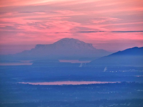
This is a photo of a mountain which positions itself on top of these lists:
- Peaks with most Unsuccessful Attempts (Rank #1)
- Peaks with Most Ascents Using a Rope (Rank #1)
- USA Lower 48 Top Peaks by Prominence (Rank #1)
- Washington State Top Peaks (Rank #1)
No other peak has the combination of high elevation, massive bulk, and extensive glaciation--and Mt. Rainier stands alone in splendid isolation, with only 40 miles separating sea level at Puget Sound from its glacier-clad summit. No other peak nearby even remotely challenges its supremacy.
In most of the United States, a hike of 3000 vertical feet to the summit of a peak is considered about average; 4000 to 5000 vertical feet is considered a very long and extremely tiring trip, and anything above 6000 vertical feet is rare and devastatingly difficult. However, Mt. Rainier, by its easiest route, requires ascending 9000 vertical feet (that's 2740m for you non-Americans).
PHOTO: Mt. Rainier, WA as seen from Dinkey Peak, Mt. Seymour. Hard to believe, but from the surface of the water to the top it is 4.4 km up! 8)

Climbing Notes:
As of 2007, the National Park Service allows three professional guide services to conduct clients to the summit of the peak and to offer mountaineering programs on its slopes. A three-day trip generally costs about $800 to $1100 and includes a day of training, a day to hike halfway up the peak, and a long third day when you summit and return to base.
Any well-coordinated and experienced hiker in excellent physical shape can make the climb with the guide services. The biggest variable is the weather--if the date of your scheduled climb is stormy, you might not even make it past the halfway camps of Camp Muir or Camp Schurman (but they still take all your money). Also, be aware that many guided climbs end at the crater rim, a short trip from the true summit at Columbia Crest.
It is certainly possible for very fit and experienced mountaineers to climb the mountain without a guide. You do have to register with the National Park rangers and pay a small fee, but beyond the sheer scale of the peak the easier routes don't present much of a challenge to those used to crossing glaciers. The Camp Muir-Disappointment Cleaver route is usually a wide, trenched-out path made by hundreds of climbers every day, including the 30-strong RMI guided group.
Other routes offer more solitude and/or challenge. The Interglacier-Emmons Glacier route is the second most-used, and avoids the crumbly rock of the Disappointment Cleaver for an endless glacier trudge. The Liberty Ridge on the northwest is perhaps the most famous of the more difficult routes, which vary all the way to the nearly-impossible Willis Wall, a 4000-foot north face of crumbling rock and ice.
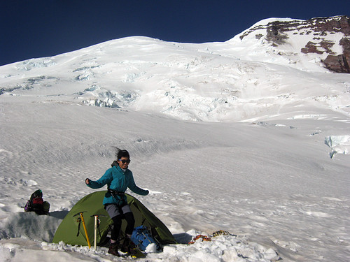
On July 9 of year 2014, Vera and I arrived at camp Schurman from camp Curtis where we spent the previous night. After setting up the tent we left for a walk up the Emmons-Winthrop Glacier route, just to "check out climbing conditions" - we were planning to stay one day acclimatizing to the altitude (3,105 m) and go for the summit (4,392 m) the next day. It was 10:00 a.m., climbers were coming down from the summit that day - traditionally, climbing Mt. Rainier begins at around 1:00 a.m. Everybody was asking us what we were up to "being so late" on the mountain. We also observed a guide pulling on a climbing rope two exhausted bodies (alive, but absolutely not able to walk). One passing body told us (without stopping obviously) it was a "Mountain Madness" commercial trip. They didn't ask us anything. We of course carried all the glacier gear with us and were roped up - no kidding, the glacier starts right from the tents. Our progress was easy (no wonder it felt very light,almost like a walk - after coming up to camp Schurman carrying ~45lbs packs each with all the climbing and backpacking gear) - very soon my altimeter indicated that we were half vertical elevation to the summit. So naturally, the idea "why not today?" occurred to both of us at the same time. I don't remember we even spent time discussing it - we just nodded in agreement and continued going up. We pushed on and reached the summit in a few short following hours, had quick lunch hiding from wind and then headed down. On the way back Vera had some exciting air-time falling some steep step, face down, missing a crevasse by only few meters (roped up of course) and I also dropped to the waist over a totally hidden snow-bridge, but nothing more serious. We were back at the tent just before sunset.
PHOTO: Our tent at camp Schurman, next day on Jul-10 2014. We would be standing back on the summit second time, arriving just from the other side, next year (2015 via Ingraham Direct route).
 |
|