|
|

楼主 |
发表于 2017-4-4 02:51:19
|
显示全部楼层
2017.03.19 Lady Mountain, East face (YDS 5.4) - Zion National Park, Utah (contd.)
Photo: Towards saddle between Lady and Jacob Peak, just before the descent at 16:26. It is getting late and a long way down. An emergency night on the mountain could become a reality, we both agreed: if it would, it would be a chilly and windy one on some narrow ledge.

The route is only ~3 km long, and ~800 m high, Grouse Grind, roughly..8)

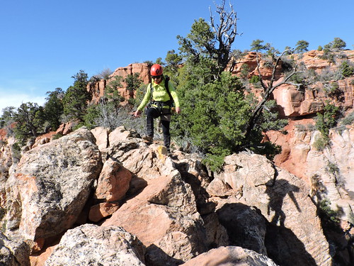
Descent. No mistakes please: typical exposed terrain of the East face of Lady Mountain. It is very important to remember turn points during the ascent, because it is easy to get lost: here you can actually see the marker-cairn on Vera's left, 3-4 meters away. We took mental note that upon return we shouldn't go down at this point, even though it looks "natural".

Summary: https://www.crossna.org/forum.ph ... post&pid=177167 |
|
 [复制链接]


 IP卡
IP卡 狗仔卡
狗仔卡
 显身卡
显身卡 发表于 2017-4-2 15:56:52